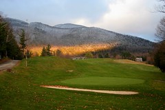
Found this shot while I scanning through this seasons hiking photos. It was taken as I walked across the Ausable club to the hiker entrance to start my walk last weekend. I like the way the band of early morning sunlight cuts across the mountain above the club seperating the fall (below) from the winter above. Winter seems to be creeping down the mountain towards the clubhouse and the golfcourse. The sunlight is holding strong for now but it's fleeting and will soon fade. While it might hold off the encroaching snows for a while, soon enough winter will press down the mountain. I think its time for me to start getting ready for those coming snows and therefore its perhaps time to put away my summer hiking gear, clean up my bike and pull out my skis. Its been a good summer but its time to move on.
Wednesday, October 25, 2006
Monday, October 23, 2006
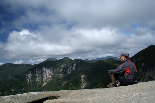
Sawteeth
I drove back to the AMR this Saturday for one more kick at the Adirondacks. Friday night had snowed heavily in Lake Placid. As I drove through town at 6am there was 4 or 5 inches of snow on the ground... why hadn't I brought my skiis!?! As I made my way around to St. Huberts and the AMR the depth of snow lessend and there was only a dusting of snow in the valley when I pulled in to park. Despite this I figured I wouldn't go up any peaks today but just explore the trails around the Ausable river. As I strolled through the golf course to the trailhead I got a good view of Sawteeth. It had a little cloud stuck on its summmit but it didn't look too bad. I decided to make for this trail and see how far I could get. The watchman at the sign-in hut advised against high mountain travel as there had been a lot of snow and ice on the summits. I advised him I would take care and not go too far beyond my abilities... little did I know. The club has closed up for the winter and there was little activity on the lake road or at the boathouse. I was early on the trails and didn't see anyone else until later in the day - what a difference from the Columbus/Thanksgiving weekend when I was last here. It was shaping up to be a great (albiet somewhat snowy) day on the trails.
The snows of November come early
Lots of snow on the ground at higher elevation. I hadn't planned to try the ascent of Sawteeth but as I made my way closer and closer the summit started to have a pull on me. I couldn't make it all the way up here and not go to the summit? Just before the final push to the summit I met someone coming down. "Pretty treacherous up there!" he said. He was wearing shorts and trail runners. The weather was 29F with a strong wind blowing through the trees. Could this guy be relied upon for wise trail advice? I chose to disregard his wisdom and pushed on.
Nevertheless it proved a difficult task as, reaching the 4000ft mark, the trails were coated in thick ice and footing became a challenge. By this point my hands were pretty cold (I'd only brought my fingerless wool gloves thinking I wouldn't be going for the top) and now they were required to grab snow covered trees and frozen rocks to insure I could pull myself up. By the time I reached the summit my hands were frozen solid. The views were less then spectacular as a low cloud clung to the summit and the Great Range was fully clouded over. I could see a little of the valley below but it was not the view I had hoped for. Nor was it the relaxing summit upon which I could enjoy my lunch and take a few pictures. With a treacherous descent waiting for me and my hands like blocks of ice I didn't stay long on top but slowly headed back down to safer trail conditions. Once I got to a lower elevation - and regained the use of my hands - I set up this shot using my hiking stick as a unipod. It was a beautiful day and - had I been better prepared - I would have enjoyed summiting the mountain a little more.
Nevertheless it proved a difficult task as, reaching the 4000ft mark, the trails were coated in thick ice and footing became a challenge. By this point my hands were pretty cold (I'd only brought my fingerless wool gloves thinking I wouldn't be going for the top) and now they were required to grab snow covered trees and frozen rocks to insure I could pull myself up. By the time I reached the summit my hands were frozen solid. The views were less then spectacular as a low cloud clung to the summit and the Great Range was fully clouded over. I could see a little of the valley below but it was not the view I had hoped for. Nor was it the relaxing summit upon which I could enjoy my lunch and take a few pictures. With a treacherous descent waiting for me and my hands like blocks of ice I didn't stay long on top but slowly headed back down to safer trail conditions. Once I got to a lower elevation - and regained the use of my hands - I set up this shot using my hiking stick as a unipod. It was a beautiful day and - had I been better prepared - I would have enjoyed summiting the mountain a little more.
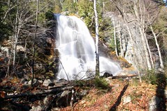
Beaver Meadow Falls
After the climb up Sawteeth I worked my way back to the car along the West River trail. This trail follows along the Ausable river which has dozens of waterfalls and rapids. Along the trail are large tributary flumes of water coming down the mountains to fill up the river. They were probably flowing at their peak as it had rained for the last week and now with the snow melting there was lots of water pouring down every stream and creek. The day had actually warmed up in the sun and the snow at lower elevation was melting fast. It was actually a little annoying as it seemed like it was raining under the tree canopy with the snow rapidly melting in the sun. Still there was lots to see and I enjoyed the walk out stopping often to catch another picture of a waterfall such as this one.
Friday, October 13, 2006
Northern logging road
After a rest day on Sunday I decided to head out on the holiday Monday for a ride in the Gatineaus. I was well aware that - with such nice weather - the southern end of the park would be overrun with leaf peepers so instead I made the long drive up to the northern end of the park and went riding on the abandoned logging roads that weave through the park. I met no one all day!
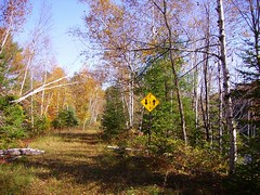
This photo is of a handy sign posted on an abandoned logging road which reminds me that I am on a two way abandoned road. Its always wise to stay to the right on abandoned roads in case you come across a deer, moose or bear heading in the opposite direction. Hate to have a head on collision as animals never use their turn signals properly and it would be tough to check for their insurance forms.
This photo is of a handy sign posted on an abandoned logging road which reminds me that I am on a two way abandoned road. Its always wise to stay to the right on abandoned roads in case you come across a deer, moose or bear heading in the opposite direction. Hate to have a head on collision as animals never use their turn signals properly and it would be tough to check for their insurance forms.
Thursday, October 12, 2006
Upper Ausable
I drove down to the Ausable club hoping to get a late start which would let the ice melt (if there was any) off the trails. When I got to the parking lot I was stunned to see it was full (50 cars at 8:30am!). I drove down the road to another lot but it was the same deal. Upon returning to the Ausable club lot I spotted one hiker parking his car on the shoulder of the highway so I decided to do the same. I grabbed a spot in front of him (checking first for no parking signs ) and then hustled to get my gear together and head up the road to the trail head. When I returned later in the day there were many cars parked along roads clear labeled as "no parking" and they all had tickets on their windshield... but I managed to avoid that fate.
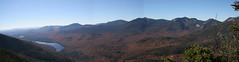
The trailhead at the Ausable club is unique in that you have to park ~ 1km away and then walk up through their private golf course and country club to the trailhead. Once signed in there is a relatively flat 3 mile walk along a gravel road(private) which gives club members access to their boathouse on the Lower Ausable lake. Foot traffic is permited on this road and finally one gets to the actual trail. I climbed up over Colvin and Blake peak today.
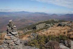
The summit of Colvin provides a super vista over the Upper (pictured) and Lower Ausable lakes and the great range. I enjoyed its summit under sunny skies and to my surprise mostly by myself. The walk over to Blake peak is an out and back affair (most high peaks hikers hate this part) over some fun scrambly terrain. No view on Blake (probably what irks the high peaks hikers) as the summit is in the trees so I didn't stay long but upon turning back to Colvin I started to hit the holiday crowds.
These peaks are usually pretty quiet but the beautiful weather and the long weekend brought out a lot of people and I started to feel like I needed turn signals to get in and out of the lines of hikers. The main summit of Colvin (on my return trip ) was jammed with hikers. People were forced to stand in the trail and wait their turn to get up on the summit rocks for a look at the view. This was not the wilderness experience I was looking for so I was glad to have been the "front edge" of the hiking crowd today getting my turns on the summits in relative quiet before the crowds arrived.
The trailhead at the Ausable club is unique in that you have to park ~ 1km away and then walk up through their private golf course and country club to the trailhead. Once signed in there is a relatively flat 3 mile walk along a gravel road(private) which gives club members access to their boathouse on the Lower Ausable lake. Foot traffic is permited on this road and finally one gets to the actual trail. I climbed up over Colvin and Blake peak today.
The summit of Colvin provides a super vista over the Upper (pictured) and Lower Ausable lakes and the great range. I enjoyed its summit under sunny skies and to my surprise mostly by myself. The walk over to Blake peak is an out and back affair (most high peaks hikers hate this part) over some fun scrambly terrain. No view on Blake (probably what irks the high peaks hikers) as the summit is in the trees so I didn't stay long but upon turning back to Colvin I started to hit the holiday crowds.
These peaks are usually pretty quiet but the beautiful weather and the long weekend brought out a lot of people and I started to feel like I needed turn signals to get in and out of the lines of hikers. The main summit of Colvin (on my return trip ) was jammed with hikers. People were forced to stand in the trail and wait their turn to get up on the summit rocks for a look at the view. This was not the wilderness experience I was looking for so I was glad to have been the "front edge" of the hiking crowd today getting my turns on the summits in relative quiet before the crowds arrived.
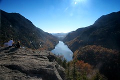
Lower Ausable
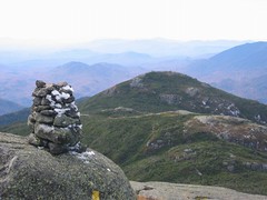
After returning over Colvin and Blake I decided to descend down to the Fishhawk cliffs and Indian Head. They are nice promintories that stick out over Lower Ausable lake. It was a beautiful fall day by this point and there was (again) a big crowd on the summit of Indian Head. I took a moment to click some pics and eat a small snack before heading down the Lake road to the car. The crowds were returning from all the various trails and a long string of groups could be seen on the Lake road out to the Ausable club. A lot of happy hikers.
When I got back to my car there was a huge number of parked cars along the highway. Close to a mile (on both sides) of the road was lined. This didn't bode well for me finding accomadations. The two state parks were full, motels were full and I decided there would be no point checking on South Meadow. As a result of the large crowds I decided to head for home rather then spend another night in the truck. It had been two great days of hiking so I was only a little disappointed - besides the two hikes had taken there toll on me so a rest day was welcomed.
When I got back to my car there was a huge number of parked cars along the highway. Close to a mile (on both sides) of the road was lined. This didn't bode well for me finding accomadations. The two state parks were full, motels were full and I decided there would be no point checking on South Meadow. As a result of the large crowds I decided to head for home rather then spend another night in the truck. It had been two great days of hiking so I was only a little disappointed - besides the two hikes had taken there toll on me so a rest day was welcomed.
Wednesday, October 11, 2006
Lake Placid
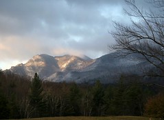
After our hike on Friday Mike had planned to hit a motel - he's not a camper... yet - while I was going to camp somewhere. It quickly became apparent that there was no vacancies to be had. Leaf peepers( and apparently circus performers, and car show enthusiasts and.... ) had taken all the motel rooms. In the end Mike decided to head for home but not before we had dinner and a beer to celebrate the (almost) end of hiking season and the successes of the '06 climbing campaign. After he headed home I went back to South Meadow and was able to squeeze my car into a spot and slept in the back. All night long, more and more cars arrived (South Meadow is free camping!). They would park in various places and set up tents in the woods nearby. When I got up at 7 in the morning the place was looking incredibly crowded (apparently it would get worse through the day). This was my first indication (or perhaps second after Mikes motel issues) that this weekend was not going to be a typical weekend in the mountains.
I took this shot driving back out from South Meadow to the highway. The morning light and fog coming up from Mirror lake looked quite spectacular.

I took this shot driving back out from South Meadow to the highway. The morning light and fog coming up from Mirror lake looked quite spectacular.
Tuesday, October 10, 2006
Algonquin
This past weekend was the Thanksgiving long weekend. Three whole days off!!! I decided to take Friday off as well to beat the crowds and get a jump on the weekend. Well the weatherman finally complied and I was feeling healthy so it was back to the mountains for some more climbing. I planned on a 3 day trek but the "Leaf peepers" conspired against me by overrunning the Adirondacks and in the end I only stayed 2 days. First up on the agenda on Friday was the MacIntyre range. This is a popular hike so I figured it would be best to do it on Friday when the crowds would be somewhat reduced. It proved a good choice.
Algonquin,is the centerpiece of this range and at 5100 ft rivals Mount Marcy for top honours. The length of the hike isn't too bad - around 12 miles all told but the elevation adds up to close to 5000 ft for all three peaks - it made for a longer day then I expected and I was pretty beat by the end.
Mike came down Friday to do the hike with me. It was one of his favourites he told me (He says this before, during and after every hike so I've learned to ignore these comments ;-). This time tho' I think he was right. It's a challenging climb with lots of slabs and ledges, an exposed summit cone and stunning views. The upper reaches were pretty icy as the temps weren't much above 0C at 5000 feet but we were still able to make our way past the worst spots. The southern exposure, which I desended to get to Iroquois summit, was all melted and by the time we were coming back down the Northern side most of the icy slabs we had had to climb up had also melted through.
This photo is just above tree line as you push the last 800 feet to the summit. Wright mountain is just in the background. We did Wright last on our way back down. I felt it would be a shame to miss this peak since we were up here but in the end it might have been a little too much as I was really cooked by the time we got back. Either way I'll probably come back to these peaks for another stunning hike.
Iroquois
After we summited Algonquin, I headed over to Iroquois while Mike enjoyed the views and took pictures(He's already been to Iroquois before). He sent me this great shot from the Algonquin summit. You can see two little specks on the far summit. One is me while the other is the summit cairn. The trail over to Iroquois is a lot of fun with lots of little rock scrambles. I was lucky today as parts of it pass through some very wet boggy areas but the mud was a little thicker then usual thanks to the cold. It would still have been deep and muddy had I stepped in the wrong places but I was able to look for slightly more solid areas in the mud to step in rather then sinking to my knees. The return trek to Algonquin is.... ummm, somewhat less fun as the climb back up is pretty steep but it has to be done so onward I went.
Sunday, October 01, 2006
Burma road
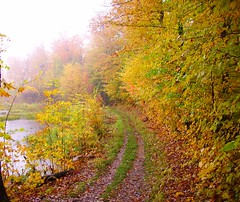
Unfortunately had to work on Saturday so I ended up staying in town this weekend. Saturday was a glorious fall day (I spent it closely analyzing a pair of concrete columns :( ) while Sunday was rainy and wet. In the end I went to the Gatineau for a run along Burma. Not sure why it is but the fall colours always look more impressive on a rainy day. Perhaps the stark contrast to the grey skies? At any rate the run was punctuated by lots of stops to take pictures along the way. Not too many people up in the park but I did run into a few diehards.
Most of the media reports on this years fall colours are saying that it will be a bust of a season. Too cold, too wet, too windy means the best colours will be lacking. From this photo you can see how terrible the colours are ;-) . Why anyone would bother to go outside and look at the foliage is beyond me ;-) I sometimes wonder why we listen to our modern media at all.... With the next few months going to be monochromatic in nature with the snowy landscape one would be well served to get out for a little overstimulation from the fall colours.
Most of the media reports on this years fall colours are saying that it will be a bust of a season. Too cold, too wet, too windy means the best colours will be lacking. From this photo you can see how terrible the colours are ;-) . Why anyone would bother to go outside and look at the foliage is beyond me ;-) I sometimes wonder why we listen to our modern media at all.... With the next few months going to be monochromatic in nature with the snowy landscape one would be well served to get out for a little overstimulation from the fall colours.
Subscribe to:
Posts (Atom)